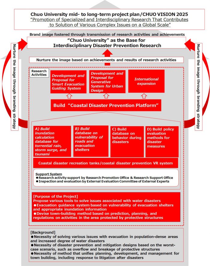
Disaster Adaptation Science Platform Development Project
Purpose of the Project
In recent years, major water disasters have become an urgent concern for coastal areas because of the larger scale of typhoons and occurrences of massive earthquakes. The areas that are threatened are not only those vulnerable to a Nankai Trough megathrust earthquake, but also in densely populated places such as Tokyo, where evacuation during storm surge, floods, etc. has become a major concern.
Before the Great East Japan Earthquake, the conventional idea was to prevent inundation with breakwater and levees. However, because the Great East Japan Earthquake exposed the limit of protection that relies on structures only, awareness of disaster prevention and mitigation has increased, as seen in a recommendation on protection policy based on the combination of evacuation when protective structures are overcome or broken and mitigation by the Central Disaster Management Council.
With such changes in policies as a background, the Flood Control Act on damage reduction in case of flood, rain, tsunami, or storm surge was revised. It is required that mitigation design be based on the worst-case scenario, including storm surge and torrential rains in addition to tsunami.
Coastal cities have a large population and standards for protective structures such as levees are high. Therefore, it is difficult to provide information on disasters and determine whether structures have been overtaken or damaged. This could lead to delayed evacuation, resulting in difficulty in evacuating the entire population in areas with risk of inundation. Not only in urban areas, but also in town buildings that combine the development of levees, there is no procedure (planning, development, and management) established yet. Furthermore, even if such a method is established, it is difficult to reach a consensus between the government and residents, and consideration must be given to possible litigation following disasters.
To solve various issues associated with the prevention and mitigation of water disasters, not a physical approach such as simply building levees, but a tool that includes a solution from a human resources point of view is necessary. In other words, evacuation guidance based on appropriate inundation information and the vulnerability of evacuation paths, and town building based on prediction, planning, and regulations on the areas at risk of inundation are essential. Therefore, this project aims to propose a method of town building based on the sustainability and the future of area activities, along with the evacuation and vulnerability of protective structures during disasters. To that end, we built a coastal disaster prevention platform that gathered inundation data for torrential rain, storm surge, and tsunami, information on the vulnerability of structures based on experimental and field data, human behavioral data during disasters, urban design data, legal precedence data on regulations associated with town building, and population prediction data. At the same time, we use the big data of this platform to develop an evacuation guiding system that sends appropriate evacuation information, as well as a generation tool for urban design that is resistant to disasters, with excessive external forces taken into consideration. Furthermore, in coastal cities around the world, we examine policies for similar platforms from the legal and economic viewpoints, and we examine the mechanism in which disaster prevention and mitigation design is developed based on the situation of each country.